Canaan Valley Site Guide
{Last Updated: Jan 2024}
Minimum
Rating: P2
Site
Direction: SW
Flyable
Directions: WNW to SSW
Glide Slope
to main LZ: about 5.2:1
Vertical: 1400’
Type of
Launch: Grassy steep slope in medium
slot
Type of LZ: Grass
field
Soarable: Ridge, thermal
Location: At top of the Canaan Valley Ski lift
Turnaround:
Time: 20 Min drive
Launch Coordinates: 38.999001, -79.434348
Parking at launch: Unlimited at Ski Resort
Parking at landing zone: 10 cars near Church
Owner Launch: Canaan Valley Resort State Park
Owner LZ: David Miller
Setup/Breakdown:
launch unlimited /LZ unlimited
WARNING: The descriptions of typical flying
conditions listed in this site guide reflect the experience of the authors of
the guide. The conditions that you encounter at the site may differ, sometimes
substantially, from those encountered by the authors. The descriptions of their
experiences may not be relevant to the likely experience of any other pilot,
particularly one who is relatively inexperienced or new to the site.
A decision to launch is always that of the
individual pilot. When deciding whether or not to fly,
a pilot may wish to take into account the descriptions in this site guide but
must also consider numerous other factors including the pilot's training and
experience, familiarity with the site, equipment, physical and mental condition
and the specific weather conditions in existence at the time of the decision
along with what the conditions may change to.
IMPORTANT!
● USHPA
membership required.
● Seek a
site introduction and walk the LZ to be sure you understand the preferred
landing approach.
● Ball up
your glider and move off the LZ as soon as possible.
● Be aware
of severe sink if the wind is from east of south. Fly out of the slot before getting into your
harness!
Emergency Help
● Canaan
Valley Fire Department
(304) 866-7450
●
Canaan
Valley Resort State Park (304) 866-4121
●
911
Directions to Site
● Rt
32. Look for the Canaan Valley State Park, Ski Hill
General Description
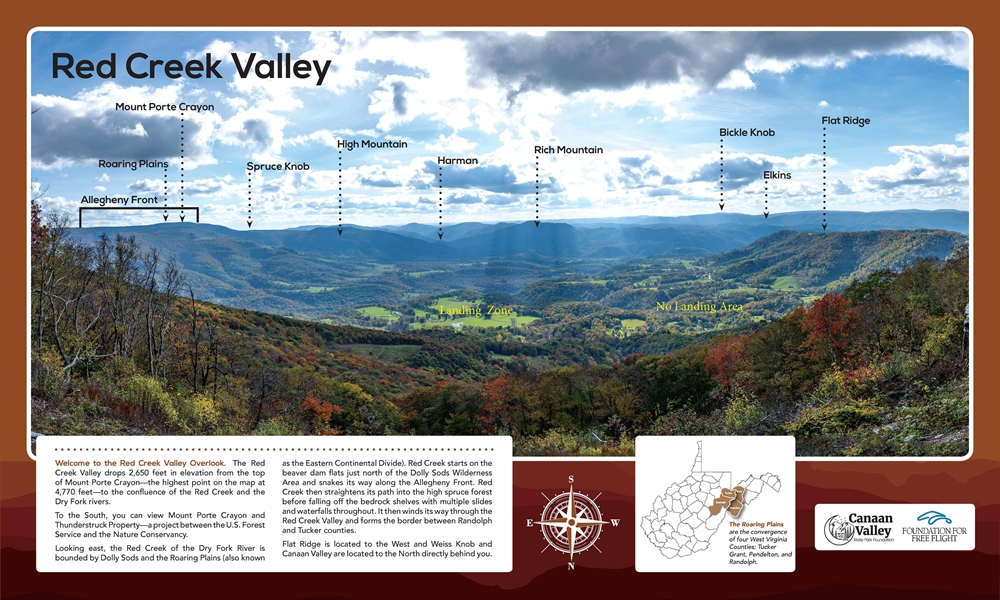
The Canaan Valley State Park paragliding site is
located atop the Canaan Valley Ski Hill. The site is accessed via the ski lift
by purchasing a single lift ticket. A view from the launch is shown below.
First Flight Preparation
Before the first flight, new or visiting pilots
must get an in-person site briefing and walk the LZ to identify various
potential issues and obtain an explanation of the landing approach.
Acceptable Flying Conditions
The Canaan Valley Launch faces SW and is flyable
from WNW to S wind directions. Thermal activity can be present starting mid-day.
This site is acceptable for pilots with a P2 rating and have sufficient
experience with thermic conditions.
The normal wind speeds for flyable days are
between 4 to 15 mph. The site allows for both ridge soaring and thermalling and is known for good glass off conditions.
Weak gusts may exist as mild thermals pass through. Flying is not recommended
if gusts are higher than 10 mph differential.
Launch can be very turbulent on a West cross due
to the spine to the right of launch.
Obstacles
The launch is surrounded by tall trees and is
considered a typical East Coast slot launch.
The LZ is open. The site allows for an S-pattern
landing path into the prevailing wind direction and when with enough altitude a
standard airport approach landing is recommended. The site is within glide of
launch. If a pilot encounters sinking air, two bail
out landing zones are available on the way to the primary LZ.
Spectators
The site can have spectators due to the ski lift
and the Red Creek Valley overlook located adjacent to launch. The spectator area is plainly segregated from
the launch. As a result, spectators do not conflict with pilots.
Glider Control
Pilots are advised to have their wings balled up
with their harness on top of it when not in use. Space is available for only
one wing to spread out and launch at the site.
At the LZ the pilots should take their wing to
the side and pack it up.
Site Images
A view from
the Canaan Valley Launch is shown below.